That planning in the urban environment is significantly changing in the digital era. Digital Twin of Urban Planning has become one of the most groundbreaking ideas, where planners of the city create a living virtual environment of a whole city. It is a digital simulation of the real-world systems that allow the simulation, analysis and optimization of the operations in the cities. Digital twins are transforming the process of urbanization through linking the physical and digital space, infrastructure and sustainability management.
What Is a Digital Twin For Urban Planning?
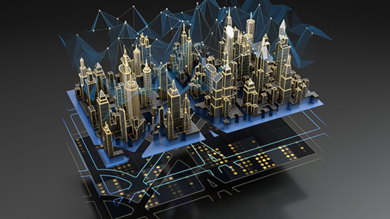
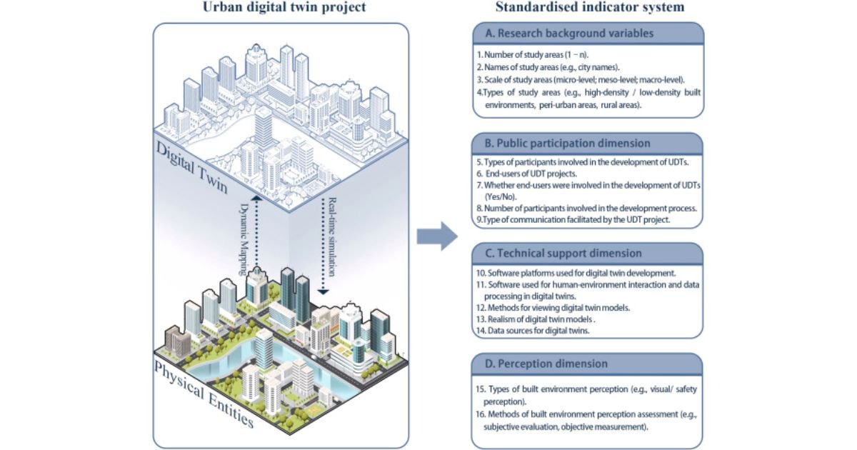
A digital twin for urban planning environment or city 3D virtual representation in real-time, based on data. A digital twin is an ever-evolving map; unlike typical maps or a CAD model, it incorporates real-time information through sensors and IoT devices and geographical information systems. Such a data flow ensures that this model is kept in tune with the actual conditions in reality.
Suppose a city is digitally reflected in terms of traffic congestion, energy consumption, air quality, and the level of population density. As planners have such a system, they are able to identify some complex patterns with their forecasts of the changes in the future as well as test the possible scenarios prior to making the policies. A digital twin enables all buildings, roads, and parks to be seen not merely in 3D, but also as a living digital ecosystem, which updates in real time.
As an example, the Virtual Singapore of Singapore is a strong instance of a nationwide digital twin. It gives city planners a multifaceted platform to plan, simulate and control all the aspects, such as traffic and the consumption of energy, effectively.
The Urban Planning of Digital Twins
Digital twins can serve as a link between the physical world and the digital world. They can be driven by such advanced technologies as IoT, AI, 3D modeling, GIS, and cloud computing. These aspects are combined to give a comprehensive picture of the functioning of a city.
1. Data Integration
A digital twin for urban planning collects data through various sources such as satellite images, sensors, traffic sensors, weather sensors and environmental sensors. This is to make sure that the virtual model is up to date in terms of the state of the city.
2. 3D and 4D Visualization
It is not a one-time model; it develops with time. In 4D modeling, planners have the ability to view the changes over a period of days, months, or even years. As an example, it enables them to model seasonal traffic patterns, construction or flood conditions.
3. Real-Time Simulation
Digital twins are the replication of real-life conditions in real time. The twin updates instantly when a traffic signal alters or when a storm strikes, displaying the effects on the roads, power networks, and transport.
4. Predictive Modeling
AI algorithms examine previous data and current data to formulate what is likely to happen in the future—such as which neighborhoods might experience congestion or how climate change will impact air quality or population increase will burden infrastructure.
5. Collaboration Tools
The collaboration between urban planners, architects, and policymakers is possible on one interactive platform. This creates teamwork, minimizes misunderstandings, and speeds up approvals of projects.
Digital Twin Advantages to Urban Planning
Visualization is also not the only benefit of digital twin for urban planning. They transform the urban planning process into a smart and data and collaborative one that makes decisions about urban planning better and sustainable.
1. Smarter Decision-Making
Real-time insights enable decision-makers to consider the situation and choose the most efficient solutions within the shortest time possible. The case of a power outage can also serve as an example; in this case, the digital twin can help identify the impacted areas and redistribute the resources efficiently.
2. Effective Scenario Testing
The planners can carry out simulations before the construction of the new infrastructure. Rather, they can test the impact of new roads on traffic, the impact of new zoning on the utilization of energy, or other impacts of new green spaces on air quality, without any bodily threat.
3. Enhanced Public Engagement
Digital twins are able to simplify the complex data using 3D maps. The citizens will have access to the proposed changes and leave their feedback and this will increase the degree of transparency and trust towards the city planning.
4. Environmental action and Sustainability
The application of digital twins can support the sustainability goals in urban areas through the simulation and optimization of the utilization of energy, waste, and production. To make the decisions concerning the urban projects greener and smarter, the carbon footprint can be visualized.
5. Improved Management of the infrastructure
Digital twins allow the authorities to monitor the health of infrastructures in real-time. This can be used to predetermine the kind of maintenance that needs to be done prior to breakdown and reduce the downtime and costs.
Comparison Between Traditional Urban Planning and Digital Twin For Urban Planning
| Aspect | Traditional Urban Planning | Digital Twin Urban Planning |
| Data Type | Static (maps, CAD, spreadsheets) | Real-time and dynamic data |
| Visualization | 2D or limited 3D | Full 3D and 4D with live data |
| Scenario Testing | Manual and time-consuming | Automated and predictive |
| Collaboration | Limited to departments | Multi-stakeholder, online collaboration |
| Decision Speed | Slow and reactive | Fast and proactive |
| Sustainability Focus | Indirect and limited | Central and measurable |
Real-World Examples of Digital Twin Cities
- Singapore Virtual Singapore: Virtual Singapore is one of the best digital twin for urban planning in the world. It assists planners with visual representation of energy efficiency, urban mobility, and climate adaptation by real-time information.
- Dublin, Ireland: Dublin is deploying the digital twins to work with Bentley Systems and Microsoft Azure to help community engagement and interactively visualize infrastructure projects. It lets the population learn about the city projects online, fostering transparency and involvement.
- Aachen, Germany: Aachen created a digital twin based on mobility, which combines both elevated and ground data. It assists in controlling construction projects and forecasting traffic jams, as well as improving transport efficiency.
- Enschede, Netherlands: The digital twin of Enschede involves the use of open-source 3D information to fight urban heat islands. Planners can use the modeling of the impact of new structures on temperature and create climate-resistant neighborhoods.
- New York, USA: The MTA digital twin in New York allows the subway employees to detect the condition of the tunnels and anticipate the need to carry out maintenance, enhancing the availability of services and the safety of passengers.
How Digital Twins Help Tackle Urban Heat and Climate Change
The phenomenon of urban heat islands arises because cities are very crowded and thus they accumulate a lot of heat compared to the rest of the surrounding urban areas. digital twin for urban planning are critical instruments to address the effects of UHI and eliminate them. Planners can experiment with measures that could decrease heat accumulation, such as adding green roofs, increasing parks, or changing road designs, by combining information about vegetation, building materials, and airflow.
Enschede cities have now been able to use such simulations to map hot zones, and experiment with cooling interventions. This renders cities livable and energy saving.
Challenges in Implementing Digital Twins
Despite the fact that digital twins have massive benefits, cities have challenges with the implementation process:
- Data Interoperability: It might prove difficult to interoperate data of different systems and old infrastructure.
- Cybersecurity Risks: With more systems being connected to the Internet, they should avoid cyberattacks on city data.
- Cost and Complexity: To develop a massive twin, one has to invest in the sphere of the IoT networks, cloud storage, and computing power.
- Skill Gap: Urban areas need trained professionals who are aware of urban planning and digital technologies.
The proposed solutions to conquer these difficulties include a common data format, the focus on open platforms, and starting with small pilot projects, which can be expanded over time, as stated by the researchers.
The Role of AI and Future Trends in Digital Twin For Urban Planning
The contemporary digital twins are based on Artificial Intelligence. It helps in identifying trends, predictive analysis and automation. AI-based simulations enable planners to model complex systems, such as water networks, power grids, and mobility flows, accurately.
Future trends include:
- Added Extended Reality (XR) integration to have immersive 3D experiences.
- Connectivity using 5G to update faster and in real time.
- Introducing Digital Twin as a Service (DTaaS) to ensure affordability of solutions to smaller cities.
- Further growth of edge computing and cloud synergy in an enhanced manner.
These inventions guarantee the further development of the digital twins as the essential part of the smart city ecosystems.
Conclusion
The urban planning digital twin for urban planning is a major milestone in the growth of a city. A combination of real-time data, highly developed AI technology, and 3D visualization can provide planners with the opportunity to create safer, smarter, and more sustainable cities. Digital twins are also contributing to the development of urban planning in all its dimensions, such as the reduction of carbon footprint, mobility increase and overall citizen experience.
As urban challenges intensify and increase, using this innovative technology is not simply an innovative choice but a basic need. Digital Blue Foam (DBF) and others are already at the forefront of this transformation by offering a platform with integrated AI-assisted, real-time modeling tools that incorporate all data types to contribute to more efficient and inclusive urban planning.
Digital twins are surely the future of urban evolution, reverting urban spaces’ dominant legacy planning into intelligent, adaptive cities for the next generation.
Also Read About: TechSized com: Smart, Simple & Honest Technology for Everyone